
Pasture.io uses satellite imagery, local weather data, farm records, and modelling to help estimate pasture cover and growth across your farm.
Satellite imagery is an important part of the system, but it is not the only part. Pio also uses information from your farm, such as grazing records and paddock details, to help build a clearer picture of what is happening over time.
The aim is to help reduce guesswork, support grazing decisions, and give you a more consistent view across the farm.
The key information Pio uses
Pio brings together several sources of information to support pasture readings and growth estimates.

1. Farm Records |
2. Satellite Images |
3. Local Weather |
4. Modelling (Pio) |
|
|
1. Farm Records
Your farm records help Pio understand what has happened on the farm.
This includes records such as:
- grazings
- harvests
- fertiliser applications
- paddock details
- pasture type or land type, where available
Grazing records are especially important because they tell Pio when pasture has been removed from a paddock and where that paddock sits in the rotation.
To get the best value from Pasture.io, it helps to record a full grazing round so every paddock has at least one grazing record entered against it. If you do not have historical records, simply start from today and keep recording grazings until every paddock has been included.
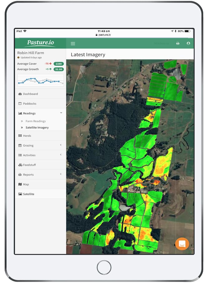
Satellite image of a dairy farm (Robin Hill, our founder's family farm) showing the variance in pasture cover within each paddock.
The best way to get Pio to hum is to enter paddock activities such as grazing and fert events into the app regularly.
2. Satellite Images
Satellite imagery helps Pio view pasture conditions across your farm.
When a usable satellite image is available, it can help inform pasture cover and growth estimates at a paddock level.
However, satellite imagery can be affected by cloud cover, haze, smoke, shadow, image quality, and local conditions. A satellite flyover does not always mean a usable image is available for your farm.
This is why Pasture.io does not rely on satellite imagery alone.
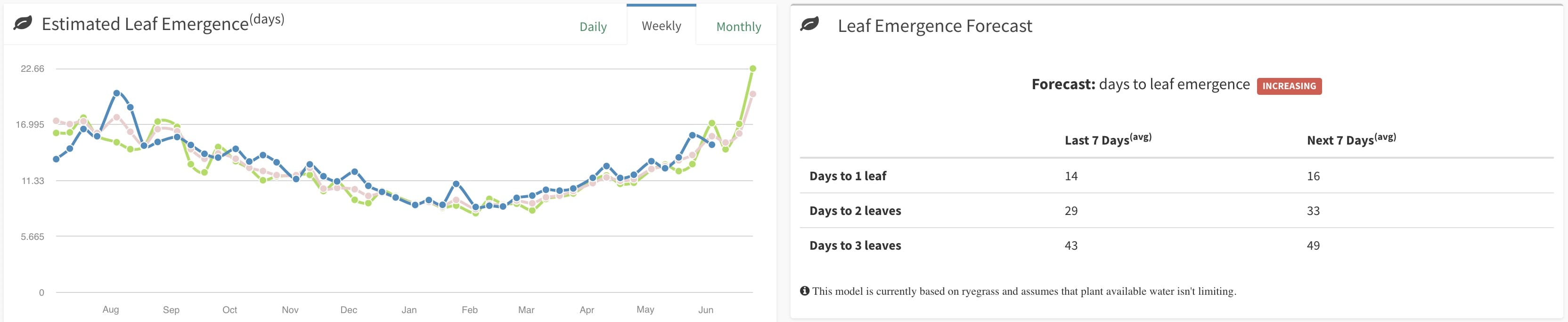
Daily leaf emergence is generated alongside pasture covers and growth rates in Pasture.io.
3. Local Weather
Weather has a major influence on pasture growth.
Pio uses local weather information to help understand growing conditions, including factors such as rainfall, temperature, and seasonal changes.
This helps support pasture growth estimates and forecasts.
Local weather information automatically streams into the app and used in the pasture models.
4. Modelling (Pio)
Pio uses modelling to bring satellite imagery, weather data, and farm records together.
This helps estimate pasture cover and growth, including between usable satellite images.
When a usable satellite image is not available, modelling can help provide continuity. These values should be treated as decision-support information and used alongside your grazing records, local knowledge, and what you are seeing on farm.
Why farm records matter
Pasture.io works best when your records are kept up to date.
Satellite imagery can show what is happening across the farm, but farm records help explain why pasture has changed.
For example, if a paddock has recently been grazed but the grazing has not been recorded, Pio may not have the full picture. Recording grazings promptly helps Pio better reflect your farm and makes pasture cover, growth rates, and grazing insights more useful over time.
Does this replace manual pasture measuring?
Pasture.io can help reduce reliance on frequent manual pasture checks, but it does not replace farmer judgement.
Manual readings, such as plate meter or cut-and-weigh checks, can still be useful as an on-farm reference point, especially when:
- setting up a new farm
- checking unusual readings
- building confidence in the trends
- comparing what Pio is showing with what you are seeing on farm
The goal is not to replace what you know about your farm. The goal is to give you a clearer view across the farm so you can make more informed grazing decisions.
What you see in Pasture.io
Pasture.io helps provide information such as:
- pasture cover
- pasture growth rate
- leaf emergence
- pasture trends
- forecasted growth
- grazing decision support
These insights are designed to help you understand what is happening across the farm and where to focus your attention.
Take-home message
Pio uses satellite imagery, local weather data, farm records, and modelling to help estimate pasture cover and growth across your farm.
Satellite imagery is important, but it is only one part of the system. Your grazing records and farm setup also play an important role in helping Pio better reflect what is happening on your farm.
The more complete and up to date your records are, the more useful Pasture.io becomes for tracking trends, reducing guesswork, and supporting confident grazing decisions.